I hadn't been in the UK for more than a few days before I was feeling overwhelmed and so thought that I should look for a nice long run to do so that I could (selfishly) have a bit of "me time". I came across the "Race Across Scotland" (an event put on by "GB Ultras") that started at Portpatrick (on the west coast of Scotland) and followed the Southern Upland Way right across the country to Cockburnspath (on the east coast).
OK, so it was rather a lot longer than I had planned on running (and an awful lot further than I had ever run before) at 345km, but in the early stages of the run, it seemed to pass by a few places where I had worked in Dumfries and Galloway, and so I figured that if I wanted to pull out, I would either be able to get myself to a train station to make my way home, or be able to ring a friend to ask them to come and pick me up with my tail between my legs. The race organisers preferred runners to have a "crew" this year (for fewer interactions at the CPs - ie keeping Covid-safe), but I did not want the pressure of having a crew give up their time for me........and in fact I did not want to tell anyone that I was going to run it, as then I could just run my own pace, enjoy it, and stop if I felt like it :-)

The race organisers (thankfully) let me enter late, but then I only had 2 days in which to get together my compulsory kit, order the map, sort out food and drink to carry (and for some drop bags to restock) and work out how to get myself over to the start. I gave myself a personal incentive to finish as one of my closest friends was going to follow my tracker and come across to meet me at the end (if I made it there) - and then take me to catch up with some other good friends for the night afterwards.....and I hadn't seen any of them in over 18 months!!!!
 |
All ready and waiting for the off...
|
Three trains and two buses later, I was collected by a friend (who was due to marshal Day 1 of the event) and taken back to her place for a good feed, a bath and bed. Unfortunately, all too soon it was 4:30am and we were up and on the road over to the start (ready for the 5:30am registration and -ve Covid test check). I try to keep myself to myself, as other runners often freak me out with their start line discussions, and this event was no exception - hearing about how much they'd "trained on the course", how many times they'd taken part before, or what kind of GPS device they had to navigate with was more than I wanted to know.....what with my last minute entry and having only just got the map to look at the day beforehand. Unfortunately there was a delay of about half an hour before we set off so I could not avoid them, but then we were off....sent on our way 2 by 2 across the line to ensure Covid-spacing was maintained.
 |
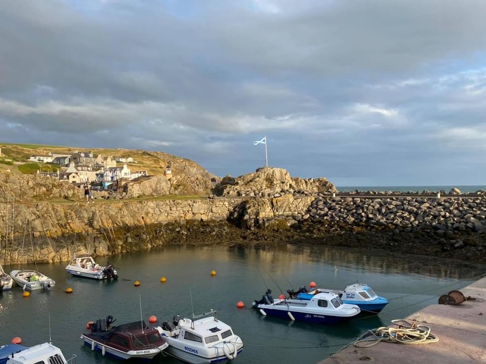
Portpatrick harbour
|
Most people only did a token run of a few metres as the "race" started with a steep climb up steps away from the harbour to the clifftop. I ran a few steps (well, there was a cameraman!!) but then decided to be sensible and walk the rest (my head, heart, lungs and legs were all in agreement with this plan!!) of the uphill and start running again once I'd reached the clifftop path.
 |
| "Running" up the steps from the harbour |
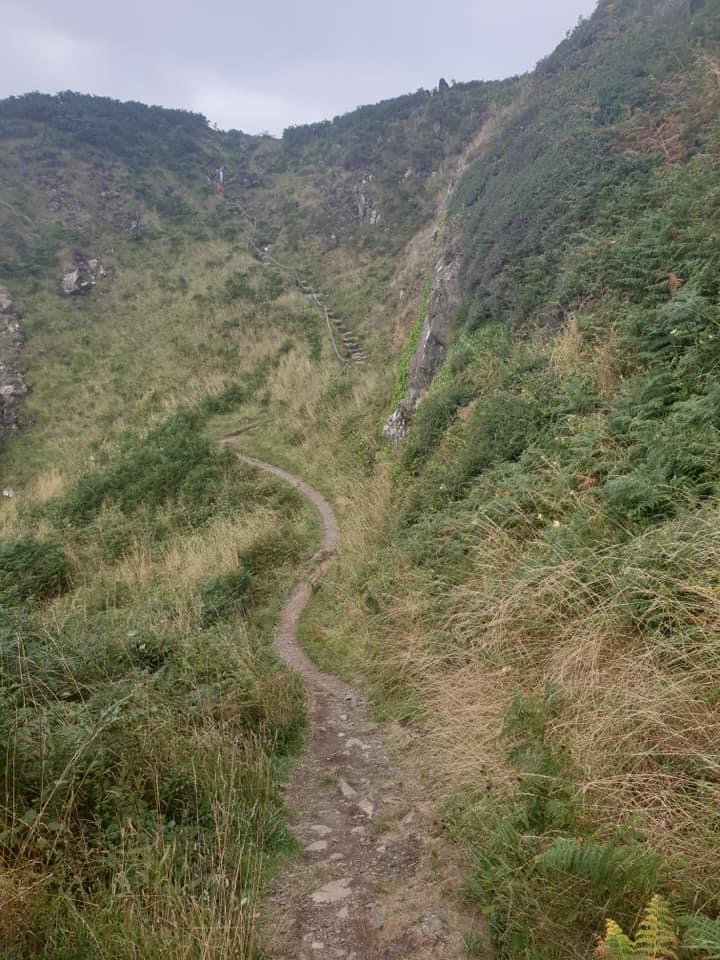
The path was narrow but there was no point in trying to pass people as we had a very long way to go and people's speed varied from minute to minute on that section as we climbed up and down to various bays, beaches and headlands. I just relaxed and enjoyed the early morning light and temperature, finding it to be an absolutely beautiful place to run, as although I'd been to Portpatrick before, I'd never actually been on that path.
 |
| The path leading round the coast from Portpatrick |
The route seemed easy to follow and I gradually passed lots of people as it seemed eminently runnable at this point, and although I knew it might come back to haunt me later, I was happy to just let my legs turn over at the pace they wanted to go. We left the coast and headed around the back of Stranraer, and I now recognised some of the roads from runs whilst locuming there, and from both the Stranraer HM and 10K which I've raced in the past.
 |
Coming into Castle Kennedy Gardens
|
All of a sudden I came across the first checkpoint, and was busy scrabbling around in my pocket for a mask when they reassured me that no mask was needed as it was an outdoor checkpoint. It was lovely to see a couple of friendly faces at the CP, and chat briefly whilst I offloaded rubbish and picked up sandwiches, cakes, bars and sweeties....and then I was off again.
 |
| Leaving the peace and quiet for the wild moors |
As soon as I crossed the main road between Stranraer and Dumfries I was off into the unknown...but what a lovely unknown it was. I loved the peace and quiet of Castle Kennedy and the contrasting wildness of Glenwhan Moor (even if some of the signposts weren't the easiest to see).
 |
Down into CP 2
|
After the next checkpoint (at the edge of a field near New Luce) there was a bit of everything....moorland, farmland, forest, standing stones, a chambered cairn and a bothy. It was in this section that I started to make some nav errors so should have spotted the warning signs of unclear route markings. There was a hidden signpost (behind overgrown foliage) pointing across a wooden bridge, which I missed so I did an extra lap of a farmer's field (funny that the farmer didn't say anything as he just waved at me from his tractor!!) before being called back to the bridge by a marshal/photographer.
 |
Snapped after the photographer got me back en route...
|
It was now quite warm so I was glad to get to the next CP, drinks a few cups and fill up my bottles......but I have to say that the hot waffles and maple syrup that I was offered didn't really appeal (there's a first time for everything) and I just opted for crisps, bars and cheese!!
 |
Refueling at CP 3
|
I was shocked to be told that I was only about 5 minutes behind the leading guys, but I guessed that they were just pacing themselves for the long haul. I started out with a run/walk as the path was narrow and wound up and down through woodland with many treeroots (and I just wanted to take the time to eat and digest the food I'd just picked up) but then the leg opened up into some more outstandingly beautiful countryside as I passed 3 very different lochs (the first of which - Loch Trool - has historic significance as it was here that Robert the Bruce defeated an English army). I also confess to getting very grumpy on the section of the route, as I had not seen any route markers for some considerable time as I climbed up a steep hill. I asked a man out walking his dog if I was still on the Southern Upland Way and he confirmed that I was...but it just didn't feel right.
 |
How many times did I see forestry/logging work?
|
Studying the map closely, I realised that he wasn't exactly correct as I was way off course and had to retrace my steps all the way back down again. I discovered that there had been no routemarkers on an important trail junction but eventually I got myself back on course and carried on past Clatteringshaws Reservoir up and over towards (St John's Town of) Dalry. It should have been another lovely run down into Dalry but again I decided to add on some extra miles to get value for money. It was getting towards evening time and I missed a dark fingerpost hidden in the shade under overhanging dark leaves.....but when I found myself a lot further down the valley than I should be (outside a power station), I realised I need to head back. The map showed a path along the riverbank that would take me back to the SUW without a long road run, but unfortunately, though I tried my hardest, this route was impassable due to nettles and brambles.
 |
Easy to see when not overgrown/fading light/dark
|
By the time I (eventually) made it into the hall in Dalry, a couple of runners (a guy and a girl running together) that I'd been about 90 minutes ahead of at the last CP were already there eating soup. Mind you, the soup looked amazing so I had a couple of bowlfuls, along with some bread and butter.....and (my reputation preceded me) some Nutella sandwiches...magic!! The other two had been strict with their time keeping and headed out again in under 20minutes, and although they had offered for me to hook up with them for the next section (ie overnight), I decided that I needed to kick back and feed myself for a bit longer. A few others came and went (meeting their support crews outside the CP) but I soon got my act together, restocked my pack and headed off as it wasn't that far off sunset by now.
 |
| Catching up with the others before dark... |
It wasn't long before I caught up to the other two as my running pace was a bit faster than theirs and so we decided to work together to get through the night ahead. I had mentioned some of my routefinding sagas with the map, compass and signposts, and though Nat said she was just using the map, she had the backup of her friend's GPS device all the time to check directions/navigation. This was definitely a big bonus for trying to find our way in the dark, as we were into some significant upland now, passing the second highest summit of the whole route at some point in the night. I would have thought this to be a lovely scenic section for walking in the daytime, as the map showed some significant areas of open moorland that would have had great views (along with some famous stone arches built by a local artist).
 |
The Southern Upland Way markerposts - easy to spot in daylight!!!
|
We dropped down into some woodland and must have become too complacent as we trotted along a forestry road chatting away (either that or the cold and tiredness was getting to us), as we missed a painted pole making the turnoff onto a small track. I admit to seeing the pole and thinking "that looks pretty" but without registering that it could have been a significant marker. We finally realised and each blamed ourselves, as we headed back down the hill again to the post and onto the SUW again. Having topped out on the next stretch of moorland, we could see the lights of Sanquhar twinkling below us (a very welcome sight for me as I was very cold and tired by now....and, having worked at Sanquhar a few times, I knew there was a trainline back to Dumfries from there!!).
For a long time, the lights never got any closer, but eventually we found ourselves running amongst houses again. I thought we should head right towards the centre of town but Nat thought the CP was to the left - and I was happy to trust her as (being both an adventure racer and an army medic) she was much more used to operating on little sleep than me. Unfortunately, this meant an extra loop of a mile or so back to the CP, but when we finally got there, we were given hot pizza.....it may have been 3:30am but it was delicious and I eagerly devoured it!!. Nat decided to head straight back out again, but the other two of us were definitely up for a rest so headed to the back room and found some camping mattresses. It was cold so a volunteer kindly lent me a thin cover to put over myself as I was wearing all my clothes, but even with it over my head, it didn't drown out the snores coming from the other mattress which started after all of about 5 seconds.
 |
| The Sanquhar Tollbooth CP |
Although I didn't exactly get the sleep I wanted, I really benefited from lying down and stretching out my legs and resting for a couple of hours, and was then back up eating pizza again (I'm calling it breakfast this time) and thinking about setting off as it was daylight by now. Unfortunately I was going to head off solo, as my nighttime buddy was pulling out and catching the train, but I'd heard that some other guys had left about 30minutes ahead of me, so there was a chance I'd see them later in the day. Once I got back onto the SUW I was in a better place, as this was a segment I actually knew fairly well, having been for little runs up and down those hills on my lunchbreaks at the surgery in Sanquhar. I knew it would be boggy and slow going, but to be honest, my shoes and socks were already so wet from the earlier sections that it made little difference.
 |
| These markers were clear to see on the stiles above Sanquhar |
I've climbed up out of Sanquhar a few times (though admittedly this time was probably a lot slower than on those occasions) but have never gone over the top and down the other side to Wanlockhead (Scotland's highest village). From the stile at the pass it looked like a nice run down to the valley floor but unfortunately it felt like trenchfoot was setting in from my soggy shoes and socks. Not only were my quads protesting at the descent but my feet were very sore too :-( At least the old road up the valley towards the village was a much kinder surface and gradient for me to run along, and the old lead mining heritage gave me things to look at and take my mind off my feet. It's funny that although you feel you're suffering alone, you gradually realise that other people are suffering just as much, and I actually caught and passed the two men ahead of me just before I got to the Wanlockhead CP. A really nice touch was that one of the volunteers (and his dog) came out and guided me in for the last 500m as the half was slightly off the SUW and (after I'd had a drink and nice veggie sausage butty) directed back onto it again - it was so nice not to spend ages wandering around looking for it!
 |
| The Lowther "Golf Ball" |
On leaving Wanlockhead, you can see the huge "golf ball" on top of Lowther Hill (the highest point on the SUW) - and you get to see it for a good while as the climb up to it is rather long and steep (and even when you reach the top it still towers over you). If you have functioning feet and legs then you can relax and enjoy the views as you cross the Dalveen Pass and go down through woodland towards Daer Reservoir (again, visible from a long way off). After crossing (what seemed like) the longest dam ever, I did enjoy the views (and the breaks I took to look at the views) back across the water as I climbed up the other side. I wasn't running very much as my legs and feet were giving me a lot of grief, but I knew that the next CP was at Beattock, and I had a drop bag to look forward to there (and friends living nearby if I needed a lift home).
 |
| "Enjoying" the moors |
The "crooked road" that leads down to Beattock also feel like home turf (I used to hold the Strava crowns for it) as we have had club runs up and down it in the past, but I had to get to it first.....which appeared to be no mean feat! Not only was there a long stretch of forestry with no waymarkers or other signposts (and so clearly I thought I'd gone the wrong way yet again!!), but when I did eventually spot a post, it was a good few metres off the track to my left in some undergrowth. Having made so many errors earlier by ignoring/missing the waymarkers, I decided to venture off my "obvious" path onto what looked like a possible old overgrowth one. After crashing around for some time and not getting anywhere, I headed back the way I'd come and continued on my previous trajectory, hoping I'd eventually find the road. I've no idea why that post was positioned where it was, as the original trail was the correct one, and yet again, I'd entertained anyone watching my tracker with my random detouring around the place!! As I "ran" down the crooked road I made lots of bargains with my feet and legs that if they just got me to the Beattock CP (nooooo.....another detour off route and into town!!) then I'd give them some proper TLC....and they did it!


No comments:
Post a Comment